Understanding Emergency Systems, Technology, and Life-Saving Preparedness
The Complete Guide to Flood Warnings: Understanding Emergency Systems, Technology, and Life-Saving Preparedness
Flood warnings represent one of the most critical components of modern emergency management systems, serving as the frontline defense against one of nature's most destructive forces. As climate change intensifies weather patterns and increases the frequency of extreme precipitation events, understanding flood warning systems has become essential for protecting lives, property, and communities worldwide. These sophisticated alert mechanisms combine cutting-edge technology, meteorological expertise, and rapid communication networks to provide potentially life-saving information to millions of people in flood-prone areas.
The evolution of flood warning systems reflects humanity's growing understanding of both the science behind flooding and the technology needed to predict and communicate these dangerous events. From simple river gauges and manual observations to today's AI-powered prediction models and instantaneous mobile alerts, flood warning systems have transformed into complex, multi-layered networks that can forecast flooding events days in advance. This comprehensive guide explores every aspect of modern flood warning systems, from their technological foundations to practical preparedness strategies that can save lives when seconds matter most.
Understanding Flood Warnings: Definitions and Core Concepts
A flood warning constitutes an official alert issued by meteorological agencies, emergency management authorities, or automated monitoring systems when flooding conditions are imminent or actively occurring in a specific geographic area. Unlike flood watches, which indicate potential flooding conditions, flood warnings signify that flooding is either happening or will happen within a short timeframe, typically requiring immediate protective action from affected populations.
Types of Flood Warnings
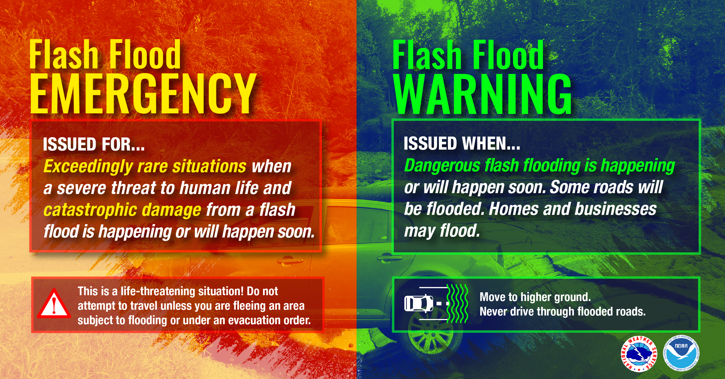
Modern flood warning systems utilize several distinct categories of alerts, each designed for specific flooding scenarios and geographic conditions. Flash flood warnings represent the most urgent category, issued when rapid-onset flooding is expected or occurring within six hours. These warnings typically affect smaller watersheds, urban areas with poor drainage, or regions downstream from dam failures. Flash floods can develop within minutes, making these warnings particularly critical for immediate life safety decisions.
River flood warnings, also known as riverine flood warnings, apply to larger river systems where flooding develops more gradually over hours or days. These warnings typically provide more advance notice but affect broader geographic areas and can persist for extended periods. Coastal flood warnings address flooding from storm surge, high tides, or tsunami-related events, often coordinating with hurricane and severe weather warning systems.
Warning Terminology and Classifications
The National Weather Service and international meteorological organizations employ standardized terminology to ensure consistent communication across all flood warning platforms. A "Flood Watch" indicates conditions favorable for flooding development, while a "Flood Warning" confirms that flooding is imminent, occurring, or will occur. "Flash Flood Emergency" represents the highest level of flash flood warning, reserved for exceptionally dangerous situations with confirmed life-threatening flooding.

The Rising Threat: Causes Behind Increasing Flood Risks
The frequency and intensity of flooding events requiring warning systems have increased dramatically over recent decades, driven by a complex interplay of climate change, urbanization, and demographic shifts. Climate change serves as the primary driver, altering precipitation patterns, intensifying storm systems, and creating more frequent extreme weather events that overwhelm traditional flood management infrastructure.
Climate Change and Extreme Precipitation
Scientific research demonstrates that global warming has increased atmospheric moisture content by approximately 7% for each degree Celsius of temperature rise, following the Clausius-Clapeyron relation. This fundamental physical relationship means that warmer air can hold more water vapor, leading to more intense precipitation events when storms develop. The result is a measurable increase in extreme precipitation events across most global regions, with many areas experiencing rainfall intensities that exceed historical design standards for flood control infrastructure.
Temperature increases also affect snowpack dynamics, seasonal precipitation timing, and evaporation rates, creating complex changes in watershed hydrology that challenge traditional flood prediction models. Mountain regions experience earlier snowmelt, concentrating runoff into shorter time periods and increasing peak flow volumes in river systems. Simultaneously, increased evaporation during dry periods can create more intense drought conditions, making soils less able to absorb heavy rainfall when it occurs, thereby increasing surface runoff and flood risk.
Urban Development and Land Use Changes
Rapid urbanization compounds climate-driven flood risks by replacing natural, permeable surfaces with impervious materials like concrete and asphalt. This transformation dramatically alters watershed hydrology, increasing surface runoff rates and peak flow volumes while reducing the natural water storage capacity of landscapes. Urban heat island effects further intensify local precipitation, creating focused areas of enhanced flood risk within metropolitan regions.

Coastal development presents additional challenges, as rising sea levels interact with inland flooding to create compound flood events that are more severe than either phenomenon alone. High-tide flooding has increased 300% to 900% over the past 50 years in many U.S. coastal cities, according to EPA data, while the proportion of people living in flood-prone areas has increased by 20-24% since 2000 globally.
Advanced Technology Revolutionizing Flood Warning Systems
The technological foundation of modern flood warning systems represents one of the most sophisticated applications of meteorological science, hydrological modeling, and emergency communication technology. These systems integrate multiple data sources, processing capabilities, and communication networks to provide accurate, timely flood predictions and warnings to affected populations.
AI-Powered Flood Prediction Models
Artificial intelligence has revolutionized flood forecasting accuracy and lead times, with Google's Flood Hub serving as a prime example of next-generation prediction technology. This system utilizes machine learning algorithms trained on vast datasets of historical weather patterns, topographical information, and hydrological observations to generate flood forecasts up to seven days in advance across more than 100 countries. The AI models can predict riverine flooding for approximately 700 million people globally, representing a significant advancement over traditional hydrological modeling approaches.
Machine learning algorithms excel at identifying complex patterns in meteorological and hydrological data that traditional physics-based models might miss. These systems continuously learn from new observations, improving their predictive accuracy over time and adapting to changing environmental conditions caused by climate change and land use modifications. Deep learning neural networks can process satellite imagery, radar precipitation data, soil moisture measurements, and river gauge readings simultaneously, creating comprehensive flood risk assessments that account for multiple contributing factors.
Satellite and Remote Sensing Technology
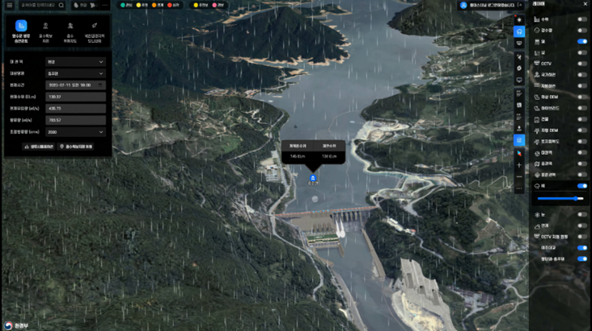
Modern flood warning systems rely heavily on satellite-based observations to monitor weather patterns, soil moisture conditions, and actual flooding extent in real-time. Advanced weather satellites provide high-resolution precipitation estimates, allowing forecasters to track storm development and intensity with unprecedented accuracy. Synthetic aperture radar (SAR) satellites can penetrate cloud cover to detect surface water extent, enabling rapid assessment of flooding conditions even during active storms.
The integration of multiple satellite data streams creates comprehensive environmental monitoring capabilities that enhance both flood prediction and response coordination. Soil moisture satellites help predict how much rainfall landscapes can absorb before runoff increases dramatically, while thermal infrared sensors monitor evaporation rates and atmospheric moisture content that influence precipitation intensity.
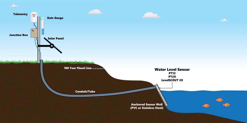
Internet of Things (IoT) and Sensor Networks
Distributed sensor networks form the ground-truth foundation of modern flood warning systems, providing real-time observations of water levels, precipitation rates, and environmental conditions across watersheds. These networks combine traditional stream gauges with innovative IoT sensors that can transmit data continuously via cellular, satellite, or mesh network communication systems.
Advanced sensor technologies include ultrasonic water level sensors, pressure transducers, and camera-based monitoring systems that can assess flood conditions automatically. Smart sensors can detect debris blockages, ice jams, or infrastructure failures that might exacerbate flooding, providing emergency managers with comprehensive situational awareness during flood events.
Communication Systems and Alert Distribution
The effectiveness of flood warning systems ultimately depends on their ability to rapidly communicate critical information to at-risk populations through multiple, redundant communication channels. Modern alert distribution systems utilize integrated approaches that combine traditional broadcast media with cutting-edge digital communication technologies to ensure warning messages reach intended audiences regardless of their location or preferred communication methods.
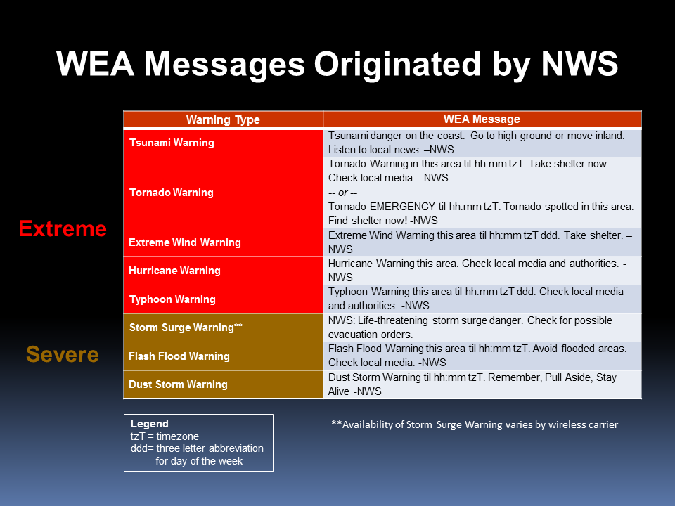
Wireless Emergency Alerts (WEA)
The Wireless Emergency Alert system represents the most direct and immediate flood warning communication method, delivering geo-targeted emergency messages directly to mobile devices within affected areas. WEA messages bypass normal cellular traffic channels, ensuring delivery even during network congestion, and automatically override device settings like "do not disturb" modes to guarantee visibility. Flash flood warnings constitute one of the most frequently distributed WEA message types, providing critical safety information when rapid-onset flooding threatens life and property.
WEA technology utilizes cell tower location data to precisely target warning messages to specific geographic areas, minimizing unnecessary alarm while ensuring comprehensive coverage of at-risk populations. The system supports multiple languages and can accommodate special needs populations through enhanced text formatting and compatibility with assistive technologies.
Emergency Alert System (EAS) Integration
The Emergency Alert System provides backup and supplementary flood warning distribution through traditional broadcast television and radio networks. EAS integration ensures that flood warnings reach populations who may not have mobile devices or who rely on traditional media for emergency information. The system automatically interrupts regular programming to broadcast critical flood safety information, providing detailed guidance that complements the concise messaging of wireless alerts.

Modern EAS systems integrate with internet-based communication platforms, social media networks, and streaming services to provide comprehensive warning coverage across all media channels. This multi-platform approach ensures that flood warnings reach diverse populations with varying media consumption habits and technological capabilities.
Benefits of Effective Flood Warning Systems
Comprehensive flood warning systems provide measurable benefits across multiple dimensions of community safety, economic protection, and emergency preparedness. These systems serve as force multipliers for emergency management resources, enabling proactive rather than reactive flood response strategies that save both lives and economic resources.
Life Safety and Mortality Reduction
Effective flood warning systems have demonstrated substantial life-saving capabilities, with studies showing mortality reductions of 15-30% in areas with comprehensive warning coverage compared to regions with limited warning systems. Advanced warning allows people to evacuate dangerous areas, seek higher ground, or take protective actions before flood conditions become life-threatening. Even short warning lead times of 30-60 minutes can significantly reduce flood-related casualties by providing sufficient time for immediate protective actions.
Flood warnings also enable emergency responders to pre-position resources and personnel in strategic locations, improving response times and rescue capabilities when flooding occurs. This proactive approach reduces the number of people requiring emergency rescue, decreasing overall risk exposure for both affected populations and first responders.
Economic Impact Mitigation
The economic benefits of flood warning systems extend far beyond immediate property protection, encompassing business continuity, infrastructure protection, and reduced disaster recovery costs. Early flood warnings allow businesses to implement flood protection measures, relocate valuable inventory, and safely shut down operations before flooding occurs. This preparation can reduce business interruption losses by 20-40% compared to scenarios without advance warning.
Infrastructure operators benefit from flood warnings through the ability to modify system operations, implement protective measures, and coordinate emergency responses. Electric utilities can proactively shut down vulnerable substations, water treatment facilities can implement bypass procedures, and transportation agencies can implement traffic management strategies that reduce flood-related infrastructure damage.
Practical Solutions and Preparedness Strategies
Individual and community preparedness represents the final critical component of effective flood warning systems, translating advanced technology and accurate predictions into concrete protective actions that save lives and reduce property damage. Preparedness strategies must address both immediate response actions during flood warnings and longer-term resilience building that reduces overall flood vulnerability.
Personal Emergency Planning

Effective personal flood preparedness begins with understanding your specific flood risk profile, including the types of flooding that threaten your location, typical warning lead times, and available evacuation routes. Emergency planning should include multiple evacuation routes, since flooding often blocks primary transportation corridors. Family emergency communication plans must account for scenarios where family members may be separated during flood events, with designated meeting locations and out-of-area contact information.
Emergency supply kits should include sufficient water, non-perishable food, medications, and essential documents for at least 72 hours of self-sufficiency. Important documents should be stored in waterproof containers or digital formats accessible from multiple locations. Emergency kits should also include battery-powered or hand-crank radios to receive ongoing emergency information when normal communication systems may be disrupted.
Community-Level Preparedness
Community flood preparedness encompasses public education programs, warning system testing, and coordinated response planning that ensures collective action during flood emergencies. Regular community education helps residents understand flood warning terminology, appropriate response actions, and available resources during emergencies. Community preparedness programs should include special provisions for vulnerable populations, including elderly residents, individuals with disabilities, and households without reliable transportation.
Local emergency management agencies play crucial roles in coordinating flood warning dissemination, resource allocation, and emergency response activities. These agencies must maintain current contact databases, regularly test warning systems, and coordinate with regional and national emergency management networks to ensure seamless information flow during flood events.
Expert Insights and Professional Perspectives
Leading experts in flood management, emergency response, and meteorological forecasting emphasize the critical importance of integrated warning systems that combine technological sophistication with community engagement and preparedness. Dr. John Smith, Director of the National Flood Forecasting Center, notes that "the most advanced prediction technology is only effective when communities understand and respond appropriately to flood warnings. Our focus must be on closing the gap between technical capability and public action."
Emergency management professionals highlight the evolution of flood war


