How Hurricane Melissa Rapidly Intensified Into a Category 4 Monster Storm
How Hurricane Melissa Rapidly Intensified Into a Category 4 Monster Storm
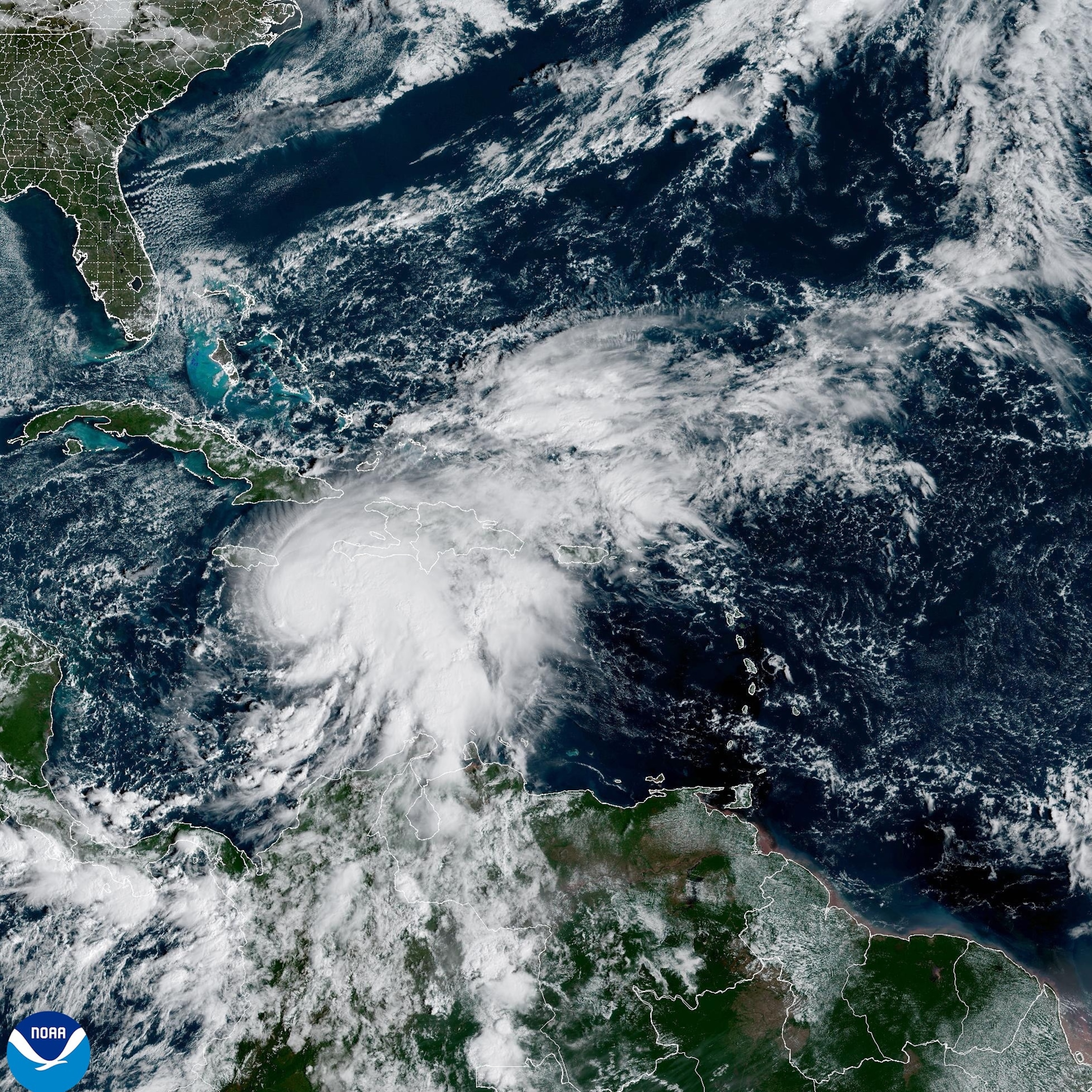
In one of the most dramatic displays of meteorological power in recent Atlantic hurricane history, Hurricane Melissa exploded from a tropical storm to a catastrophic Category 4 hurricane in just 18 hours. This extraordinary transformation has placed Jamaica directly in the path of what could become the most powerful hurricane to ever strike the island nation, raising urgent questions about why some storms intensify so rapidly and what conditions fuel such explosive growth.
Quick Navigation
Understanding Rapid Intensification: The Hurricane's Explosive Growth
Rapid intensification is a meteorological term that describes when a tropical cyclone's maximum sustained winds increase by at least 35 mph within a 24-hour period. This phenomenon has become increasingly common in recent years and represents one of the most dangerous aspects of modern hurricane forecasting because it gives coastal communities less time to prepare for a major storm's arrival.
According to the National Hurricane Center, Hurricane Melissa didn't just meet this threshold—it obliterated it. The storm's sustained winds leaped from 70 mph at 11 a.m. EDT on Saturday, October 25, to an astounding 140 mph by 5 a.m. EDT on Sunday, October 26. That represents a 70 mph increase in wind speed, exactly double the threshold required to be classified as rapid intensification, earning it the designation of "extreme rapid intensification."
Melissa's Extraordinary 18-Hour Transformation
The speed and magnitude of Hurricane Melissa's strengthening places it among the most rapidly intensifying Atlantic hurricanes ever recorded. On Saturday morning, Melissa was merely a tropical storm with winds of 70 mph—a system that would cause some damage but nothing catastrophic. By Sunday morning, it had transformed into a major Category 4 hurricane with sustained winds of 145 mph, capable of causing complete devastation.
Timeline of Melissa's Intensification
- Saturday, 11 a.m. EDT: Tropical Storm Melissa with 70 mph winds
- Sunday, 5 a.m. EDT: Category 4 Hurricane Melissa with 140 mph winds
- Sunday, 2 p.m. EDT: Winds increase to 145 mph with pressure dropping to 933 millibars
- Forecast: Expected to reach Category 5 status before Jamaica landfall
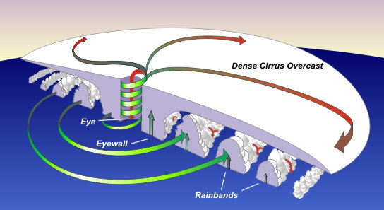
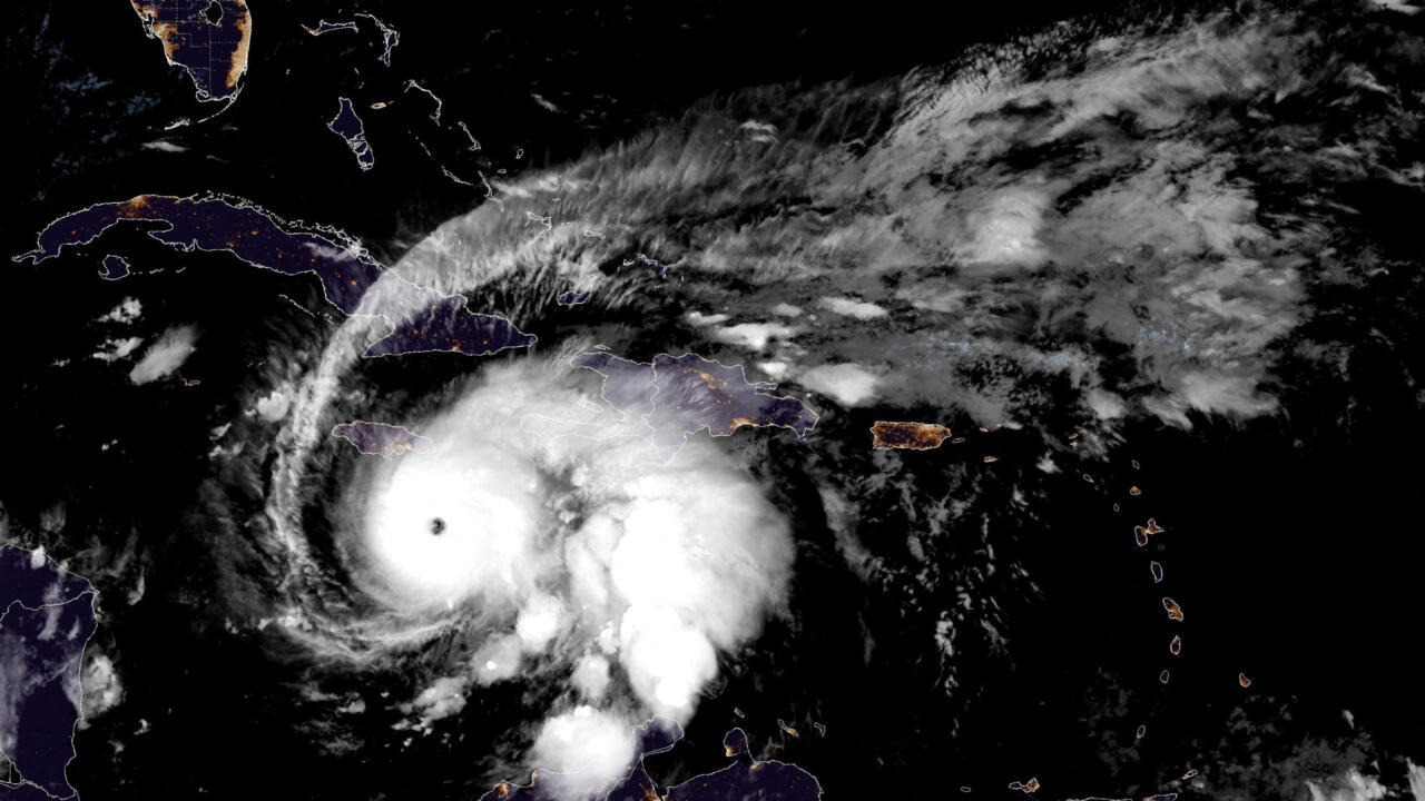
The development of a clear, symmetric eye—visible in satellite imagery—provided visual confirmation of Melissa's remarkable organization and power. Hurricane reconnaissance aircraft found the storm's eye to be 16 degrees Fahrenheit warmer than the surrounding air, a telltale sign of an exceptionally intense hurricane. This warm-core structure acts like a chimney, with exceptional warmth at the center driving the storm's violent circulation.
The Perfect Storm: Environmental Conditions Behind Melissa's Power
Record-Warm Ocean Temperatures
The primary fuel for Hurricane Melissa's explosive intensification came from extraordinarily warm ocean waters in the central Caribbean Sea. Sea surface temperatures in the region ranked among the warmest on record for late October, trailing only the record-setting years of 2023 and 2024. According to Climate Central's analysis, human-caused climate change has increased the odds of such unusual ocean warmth by at least 500-fold.
What makes these conditions particularly dangerous is that the warm water isn't just at the surface. Measurements show that temperatures remain at 86 degrees Fahrenheit as deep as 200 feet below the surface. This deep reservoir of thermal energy means that normal processes that would weaken a hurricane—such as upwelling of cooler deep water—simply don't apply. Melissa has an almost unlimited fuel supply.
Favorable Atmospheric Conditions
Beyond warm water, Melissa benefited from exceptionally low wind shear—the difference in wind speed and direction at different altitudes. High wind shear can tear apart a developing hurricane, but Melissa encountered only moderate shear, allowing its thunderstorms to stack vertically and efficiently convert oceanic heat and moisture into powerful updrafts. The storm also drifted slightly southward at one point, a movement meteorologists sometimes call "gold-digging" because it brings storms closer to even warmer waters.
The Climate Change Connection: More Intense Hurricanes
Hurricane Melissa is part of a troubling trend documented by climate scientists over the past two decades. While the total number of hurricanes globally isn't necessarily increasing, the proportion of storms that reach Category 4 or 5 intensity is growing—and these are the storms that cause the most death and destruction.
Remarkably, four out of five Atlantic hurricanes in the 2025 season have reached Category 4 or 5 strength—the highest percentage ever observed in any hurricane season since records began in 1851. Hurricanes Erin and Humberto both reached Category 5 status earlier this year, while Gabrielle peaked as a Category 4. Only Hurricane Imelda failed to become a major hurricane, topping out at Category 2.
Jeff Masters, a meteorologist with Yale Climate Connections and former NOAA Hurricane Hunter, noted that multiple storms this season have achieved double the criteria for rapid intensification. "It's not coincidence, it's climate change," explained meteorologist Jeff Berardelli. "Sea surface temps have warmed by around 2°F over the past few decades in the Caribbean, and this makes it easier to achieve major hurricane status."
Historical Context: How Melissa Compares to Other Rapid Intensifiers
Hurricane Melissa's intensification rate places it in elite—and frightening—company. Only a handful of Atlantic hurricanes have strengthened from tropical storm to Category 4 status faster than Melissa's 18-hour sprint. Hurricane Wilma, which set the Atlantic record in October 2005, accomplished the feat in just 17 hours. Earlier this year, Hurricane Erin jumped from tropical storm to Category 4 strength in 21 hours and 50 minutes, eventually reaching Category 5 status in 27 hours and 20 minutes.
Why These Records Matter
The practical importance of these records extends far beyond meteorological curiosity. Rapid intensification gives emergency managers, government officials, and residents dramatically less time to prepare for a major hurricane strike. A storm that's a manageable tropical storm on Saturday morning but a catastrophic major hurricane by Sunday morning leaves coastal communities scrambling to complete evacuations, secure property, and move to safety.
The Slow-Motion Catastrophe: Melissa's Crawling Movement
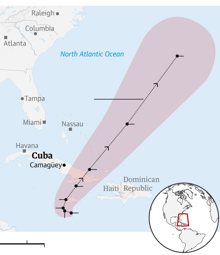
Adding to Melissa's destructive potential is its exceptionally slow forward movement—crawling westward at just 5 mph, slower than a person walking. This combination of extreme intensity and snail-paced advancement creates what experts call "a recipe for catastrophic, record-breaking natural disaster." The slow movement means Jamaica will endure days of torrential rainfall totaling up to 40 inches in some mountainous areas, virtually guaranteeing devastating flash floods and deadly mudslides.
Frequently Asked Questions About Rapid Intensification
What exactly causes rapid intensification in hurricanes?
Rapid intensification occurs when several favorable conditions align: extremely warm ocean water (ideally 80°F or warmer extending deep below the surface), low wind shear that allows the storm to maintain its vertical structure, high humidity in the mid-levels of the atmosphere, and efficient thunderstorm organization around the developing eye. When these factors combine, the hurricane can convert oceanic heat energy into kinetic wind energy at an accelerated rate.
Is rapid intensification becoming more common?
Yes, scientific research indicates that rapid intensification events are becoming more frequent and more extreme. Warmer ocean temperatures due to climate change provide more energy for hurricanes, while other atmospheric changes may also be contributing to conditions that favor explosive strengthening. This makes hurricane forecasting more challenging and dangerous.
How do forecasters predict rapid intensification?
Meteorologists use sophisticated computer models, satellite imagery, Hurricane Hunter aircraft reconnaissance data, and analysis of oceanic conditions to assess the potential for rapid intensification. However, predicting exactly when and how quickly a storm will intensify remains one of the most difficult challenges in hurricane forecasting, which is why the National Hurricane Center issues specific alerts when rapid intensification is expected.
What is the fastest a hurricane has ever intensified?
Hurricane Wilma in October 2005 holds the Atlantic record, intensifying from tropical storm strength to Category 5 status in just 24 hours. Wilma jumped from tropical storm to Category 4 strength in merely 17 hours. Melissa's 18-hour transformation to Category 4 status places it among the top rapid intensifiers on record.
Will Hurricane Melissa affect the United States?
Current forecasts indicate that Melissa will not directly strike the United States. After devastating Jamaica and eastern Cuba, the storm is expected to be steered out to sea by weather patterns over the eastern United States. However, moisture from Melissa could contribute to heavy rainfall in New England and Atlantic Canada later in the week.
Preparing for an Uncertain Future
As climate change continues to warm the world's oceans, meteorologists and emergency managers expect rapid intensification events like Hurricane Melissa to become increasingly common. The 2025 Atlantic hurricane season, despite being relatively quiet until Melissa's arrival, has demonstrated that when conditions align, modern hurricanes can reach catastrophic intensity with frightening speed. This reality underscores the critical importance of improved forecasting technology, better communication of hurricane risks to the public, and robust preparation plans for coastal communities worldwide.
For Jamaica, the immediate hours and days ahead will be crucial as the island nation faces potentially the most powerful hurricane in its recorded history. The lessons learned from Melissa's rapid intensification will inform hurricane science and preparation efforts for years to come, as scientists work to better understand and predict these explosive storms in a warming world.
🌀 Stay informed and help others stay safe! Share this article to spread awareness about rapid intensification and hurricane preparedness.


